
Walk The Bronx by Street
A street is not one record. It is a sequence of parcels, buildings, intersections, and address ranges. Begin with the exact physical address, borough, cross streets, and an approximate year if the question concerns an earlier period. The practical route is address to BBL, then BBL to recorded documents and building history. A BBL is New York City’s borough, block, and lot identifier. It stays more useful than a street number when lots merge, split, or have special condominium, air-lot, or subterranean-lot relationships.
- Enter the address in the NYC Property Information Portal, select the suggested address, and note its BBL.
- Use GOAT’s street-intersection search with the on-street and two cross streets to check the left and right side address ranges.
- Open the BBL in ACRIS, inspect the latest recorded instrument, and read the image and legal description rather than relying on an index line alone.
- Check the address, BBL, or BIN in the Department of Buildings property tools for permit, complaint, violation, and certificate history. A BIN identifies a building, not necessarily every unit within it.
- For an earlier occupant clue, record the street number and year, then consult the Library of Congress Bronx reverse-directory runs or the NYPL directory collection.
That sequence keeps parcel evidence, recorded parties, construction events, and historical address entries separate. It also prevents a result for one side of a wide avenue from being mistakenly applied to the other side.
The Bronx Street Directory PIP Routes
The Property Information Portal, or PIP, is the current address and BBL starting point. Its address route uses autocomplete and can accept an address, intersection, or common-place name. Choosing the suggested NYC address matters. An outside address returns an out-of-city result. PIP can show property details, assessed value, exemptions, recent recordings, lot history, and map or tax-map history. It does not present a direct owner-name field in the inspected public search screen. An owner-name question therefore needs a BBL-first route, an ACRIS party search, DOF roll data, or corroborating records.
| PIP field or route | Entry type | When required | The Bronx use |
|---|---|---|---|
| Borough | Dropdown | BBL and special routes | Select Bronx before entering a block or lot. |
| Block and lot | Text | BBL route | Use the tax-block and tax-lot identifiers. |
| Address | Autocomplete text | Address route | Enter a street address, intersection, or common place and choose the suggestion. |
| Condominium number | Text plus borough | Condominium route | Use the exact development identifier. |
| Co-op development number | Text plus borough | Co-op route | Use the development identifier shown by the portal. |
| REUC, air lot, or subterranean lot | Special identifier | Route-specific | Use when an ordinary address or lot relationship is not enough. |
This is a useful Bronx search quirk: autocomplete and BBL routing solve the property question, while ACRIS party and date searches solve a recorded-party question. They are related tools, not one universal owner lookup.
Note: An exemption or mailing address on a tax record is a tax-record fact, not proof that a person currently occupies the property.
Map The Bronx Street Sides
GOAT is designed for the street-segment question. Its Function3 form takes a borough, on-street, optional side of street, and first and second cross streets. The result can return geographic information, left-side and right-side ranges, a map, BBL, BIN, ZIP, census geography, precinct, community district, and council district. ZoLa adds parcel, zoning, land-use, district, and planning context. Click adjacent lot polygons in ZoLa, record each BBL, then resolve the individual lots in PIP and ACRIS.
GOAT’s street-intersection screen shows how an on-street and cross-street search distinguishes street sides and address ranges.
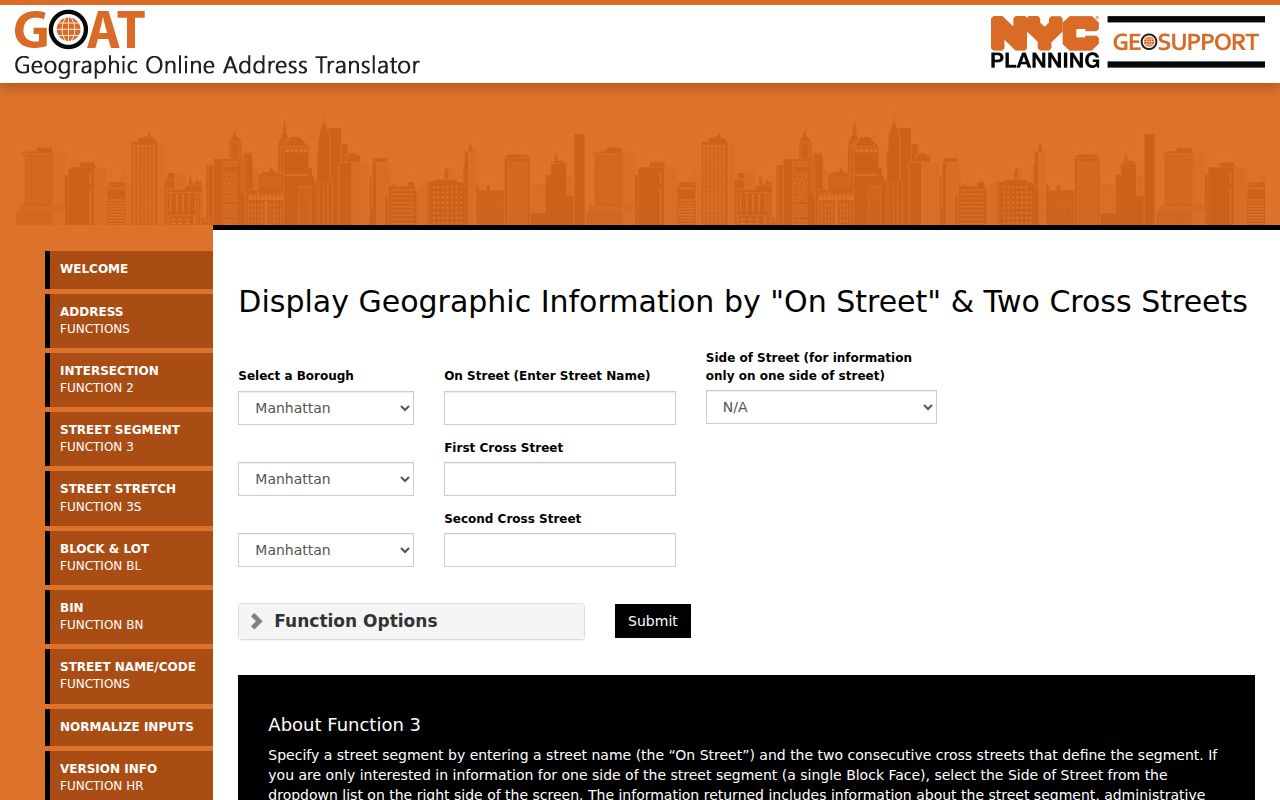
The screen is geographic evidence. It helps normalize an address and locate parcels, but it does not identify a household or produce a street-wide voter list.
The Bronx Street Directory Deed Trail
ACRIS covers recorded City Register instruments for the Bronx from 1966 forward. Search by address or BBL to resolve the parcel, then use property-document and party or date paths. For an address history, identify the most recent deed, capture the grantor, grantee, recording date, document number, and legal description, then search the earlier seller as a grantee in an earlier range. Check both grantor and grantee spellings because initials, punctuation, and abbreviations can affect an index result.
ACRIS is free to search and its personal-computer copies are free. Uncertified printed copies from the City Register office cost $1 per page and certified copies cost $4 per page. For deeds before the online cutoff, change tools: the City Register research library in Queens, historic property cards, archival material, and digitized land-record collections can supply the next lead. A recorded deed is index evidence, not a title opinion. Lot mergers, tax-map changes, easements, and entity transfers deserve their own review.
The Bronx Street Building Events
The Department of Buildings building-data guidance separates legacy BIS information from newer DOB NOW material. In BIS, Property Search can use borough plus house number and street, BBL, BIN, or a block-and-lot browse route. Related panels cover complaints, violations, applications, boilers, gas, power, elevators, and cranes. Issue-date and status fields help place a construction event in time.
A permit, violation, or certificate can anchor physical history. It does not identify every person who lived in a building. Plans and drawings may require a separate records request, and BIS does not include DOB NOW. Keep the property identifier, document number, date, and system source together when comparing this evidence with an ACRIS instrument or a directory entry.
The Bronx Street Records by Address
Each source below is keyed to an address, parcel, street segment, or known person in a different way. The list is strongest when the question is narrowed to a specific property or era. It is not a single directory of everyone on a street.
| Address record | Keeper | What it can establish | Access and limit |
|---|---|---|---|
| PIP and DOF roll | NYC Department of Finance | BBL, assessment, tax class, exemptions, and map history | Free web and data routes; no direct owner-name box observed. |
| GOAT and ZoLa | NYC Planning | Address range, street side, BBL, BIN, ZIP, districts, and adjacent parcels | Free map tools; geographic output only. |
| ACRIS | NYC City Register | Recorded deeds, mortgages, leases, liens, parties, and images | 1966 forward online; earlier research needs another channel. |
| Property cards | NYC Department of Records and Information Services | Historic ownership, conveyance notes, values, class, sketch, and tax photograph | Order route is $18 per card. |
| DOB BIS and NOW | NYC Department of Buildings | Permit, complaint, violation, and certificate chronology | Legacy and current systems are separate. |
| Criss-cross directories | Library of Congress | Historic address-to-name and phone entries | Bronx runs cover 1971-1996. |
| NYPL directories | New York Public Library | Annual name, business, and address entries | Runs begin in 1786; digitized coverage is a subset. |
The chain is address to BBL, BBL to records, and year to the appropriate historical source. When the purpose shifts to confirming one known person rather than documenting a street, use the resident-lookup resources instead of treating a parcel result as a personal profile.
The Bronx Street Directory in Earlier Years
Reverse and criss-cross directories work from a street number toward an historic name or phone listing. The Library of Congress identifies Bronx street-address directories for 1931-1973, except 1934, and 1981-1991, except 1983. Its Bronx criss-cross runs cover 1971-1996. The NYPL’s digitized New York City directory collection complements those sources, with a broader city-directory collection dating from 1786 to 1934.
Record the publisher, year, page, exact address, spelling, and notation. A reverse-directory entry is a dated clue, not current occupancy. The fuller historical reading method belongs in the Bronx city directory collections; the address-first use here is simply a bridge between a modern parcel and an older entry.
The Bronx Street Names Over Time
Historic street research can change jurisdictions before it changes names. Areas west of the Bronx River, including Kingsbridge, West Farms, and Morrisania, were annexed to New York City in 1874. Much of the east-of-river area was annexed in 1895. The Bronx became a borough in 1898 and a county in 1914. A pre-1898 search may therefore need Westchester, New York County, or town labels as well as a current Bronx address.
The Library of Congress 1935 Red Book indexes streets and correct house numbers at intersections. Compare it with GOAT, tax maps, directories, and local-law records when an old number does not fit a current map. There is no support here for claiming a borough-wide renumbering year. A ceremonial name or service-road name can also differ from the tax address.
The Bronx Street Voter Limits
New York registration records are public under Election Law §3-220, but the public web tools are individual status checks. The NYS voter lookup requires county, last name, first name, date of birth, and ZIP. The NYC voter lookup also requires borough. These fields are designed to verify a known registrant. They are not a browseable street list, and a no-match can reflect a spelling, date, ZIP, status, or confidentiality issue.
Driver-license, non-driver ID, Social Security, and facsimile identifiers are withheld. Confidential registration under Election Law §5-508 protects qualifying voters. BOE records requests have use restrictions under Election Law §3-103(5), and ballot choices are not public voter-history fields. For a records request, use the applicable BOE FOIL procedure and describe the record and lawful purpose precisely.
Note: A voter-status result cannot prove present residence, household membership, or every person associated with an address.
The Bronx Address Record Terms
Three address labels can describe the same property without meaning the same thing. Keep them separate in search notes, especially when a deed, map, and tax record appear to conflict.
- Parcel
- A mapped unit of land. In New York City, its BBL links property and recorded-document research.
- Situs address
- The physical location used by the map or building record.
- Mailing address
- The place used for tax or notice correspondence. It may differ from the situs address.
- Legal description
- The deed or tax-map description of the property, often more stable than a street label.
- Criss-cross directory
- A reverse directory arranged so an address can lead to a dated name or telephone entry.
The Bronx Street Directory Boundaries
Address records can identify parcels, recorded parties, physical work, and dated directory entries. They do not establish unindexed household members, private utility or delivery customers, protected voter addresses, DMV addresses, or sealed court and vital records. A single building can contain many units, a building can span lots, and a corner parcel can use more than one street address. Those facts explain why a neat-looking street result can still be incomplete.
Lawful use. Use Bronx address records for lawful personal research, property history, family history, and civic questions. Do not use records to stalk, harass, intimidate, or harm any person.
For a reliable street file, preserve the source URL, search date, exact address, BBL or BIN, document date, party role, and confidence level. That small audit trail makes it possible to correct an old entry without turning a property record into a claim about a household.